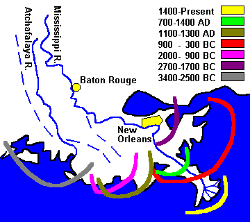
mississippi river DELTA
The Mississippi River Delta Basin comprises approximately 521,000 acres of land and shallow estuarine water area in the active Mississippi River delta. Approximately 83 percent of this area, or 420,000 acres, is open water. The 101,100 acres of land in the basin are characterized by low relief, with the most prominent features being natural channel banks and dredged material disposal areas along the Mississippi River, its passes, and man-made channels. Coastal marshes make up approximately 61,650 acres or about 61 percent of the total land area in the Mississippi River Delta Basin. Eighty-one percent of this marsh is fresh, 17 percent is intermediate, and 2 percent is brackish-saline.
The Mississippi River discharges the headwater flows from about 41 percent of the contiguous 48 states. On a long-term daily basis, discharges in the Mississippi River average 470,000 cubic feet per second. A peak discharge of approximately 1,250,000 cfs occurs on the average of once every 16 years downstream of New Orleans.
The drainage basin of the roughly 2,350-mile-long river includes about 40,000 dams and levees built over the past century. These structures control flooding and improve navigation, but they also trap sediment or funnel it completely through to the sea. Previous studies suggested that dams and reservoirs built since 1950 have trapped as much as 70 percent of the river’s natural amount of sediment. With less material feeding it, the delta plain has been experiencing erosion.
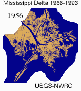
Between the mid-1950’s and 1974, the estimated land loss rate for the basin was 2,890 acres per year. This loss is the result of compaction, subsidence, hurricanes, tidal erosion, sea level rise, and human activities. The loss has been aggravated by maintenance of navigation channels and construction of canals for mineral exploration. The total land area lost in this basin over the last 60 years has been approximately 113,300 acres.