-
Technical Illustration
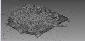
Hidden Line rendering in 3ds max is a tool to create an alternate vision to aid in the modeling process. The option is located under render setup, clicking the Quicksilver renderer (New with 2012 edition) and creating a Visual Style by choosing Hidden Line from the menu. This view does not require materials, and unlike […]
-
Models with Depth
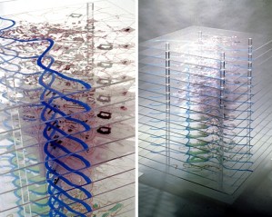
After winning the Rome Prize in 1999, Tom Leader’s chosen project was to create a temporal map of Rome. Relating time and historical data in the form of a drawing is a challenge enough, but expression in the form of a physical model is even more so. Tom Leader’s finished project relies on 15 acrylic […]
-
Organic Terrain Design
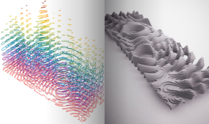
There is a wide-ranging difference in perceptions of terrain. Depending on education, experience and field of expertise the terrain can be an inspiring creative outlet. British artist Kane Cali has always used terrain to broaden his approach to art. Using some techniques that are similar to landscape architects and some that are not, he transforms […]
-
{animation: ecology of oil & gas infrastructure}
An exploration of Louisiana’s Gulf Coast landscape as an ecology comprised of an industrial oil and gas infrastructure and natural wetlands.
-
Prototype III
[framework]: Our third prototype involved continuing the development of our plaster topographical panels. Using the Analog: Digital New Orleans project as a precedent, we were able to refine the frame for our plaster mold. We utilized 2x4s held together by c-clamps to make the frame easier to put together, take apart, clean, and reuse for […]
-
protoype growing vegetation
Click here to check out how to make growing vegetation.
-
protoype storyboard v2
-
{schedule}
March 24 (wed) – have all of necessary data collected – bathymetric/elevation – breakline/surface – wetland gradient – salinity – infrastructure: oil wells, pipes, refineries, roads March 27 (sat) – transfer data into autocade files – cut scaled sections on laser cutter – material testing/experimentation March 31 (wed) – construction of larger model framework – […]
-
prototype 5.0- precision & abstraction
So with my model, I realize I need to be more precise in what I am representing. The first step towards that is to collect more accurate information. I compiled a large ArcMap document with the following data of my Golden Meadow- Port Fourchon transect: – bathymetric/topography data – breakline data (change in surface cover […]
-
Schedule
March, 2010 Wed.24 – Finish model prototype construction. Continue search for plastic particles. Sat.27 – Start Framework terrain models in Civil 3D. Collect all river profiles. Wed.31 – Continue work on terrain models and profiles(Now using Photoshop/3ds max). Model maintenance/fine-tuning. April, 2010 Spring Break – determine life of model prototype, start construction of larger model […]


