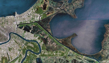
Saltwater Intrusion . MRGO
Since construction of the MRGO and other canals that are intended to increase access and improve navigation in the area, average salinity levels have risen in coastal Louisiana. The MRGO, or Mississippi River Gulf Outlet, breaches the barrier islands, which serve to shelter coastal wetlands thus exposing once protected areas to the full effects of salt intrusion. In 1989, the MRGO canal was 3 times larger in width than at original construction due to coastal erosion that resulted from activity along the canal. Although the MRGO has been closed, it is still conveying salt water into the wetlands and salinity levels continue to rise, though not as rapidly.

Salinity rose an average of 4.5 parts per thousand after the construction of MRGO, from levels as low as 6.3 parts per thousand in March before construction to levels as high as 16.1 parts per thousand in July after. Generally, saline levels, both before and after MRGO carried saltwater into Bayou la Loutre, were lowest during the wet winter and spring months and highest during the dry summer and fall months. Before MRGO, salinity in Bayou la Loutre varied by a little more than two points spring to summer, after by as much six points. In July, the saline levels in the bayou doubled after the completion of the channel.
Paired with sea level rise, heightened salinity of water can be extremely detrimental to basin wetlands. A 1999 Corps report estimated that a total of more than 20,000 acres of coastal wetlands were lost or converted due to construction of the channel and the placement of the spoil materials from its construction. Since construction, another 3,400 acres of wetlands have been lost due to increased tides and salinity resulting from the MRGO. Increased salinity also converted some wetlands from less saline to more saline habitats.Dramatic habitat shifts have occurred because of project-altered salinity regimes. At Shell Beach, salinities increased from an average of 3.5 ppt in 1959-1961 to an average of 12 ppt in 1962-1964. For example, in St. Bernard Parish, the MRGO caused 3,350 acres of freshwater/intermediate marshes and 8,000 acres of cypress swamps to convert to brackish marshes, and 19,170 acres of brackish marsh and swamp to saline marsh. One study estimated that these wetlands annually reduced hurricane damages by $520 million to $2.2 billion. Wetlands losses also have harmed economically significant fisheries, 75% of whose catches spend part or all of their lives in these coastal areas. Louisiana wetlands also are the winter home to 20% of the nation’s migratory waterfowl, as well as 24 endangered or threatened species and 20 national wildlife refuges.

Lake Borgne, part of the Ponchartrain Basin, is no longer a lake at all but more of a lagoon connecting to the Gulf of Mexico as a result of coastal erosion. The basin contains 483,390 acres of wetlands, consisting of nearly 38,500 acres of fresh marsh, 28,600 acresof intermediate marsh, 116,800 acres of brackish marsh, 83,900 acresof saline marsh, and 215,600 acres of cypress swamp. Since 1932, more than 66,000 acres (267 km²) of marsh have converted to water in the Pontchartrain Basin, which is over 22% of the marsh that existed in 1932.
